Wetland Delineation Training
Overview
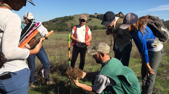
Basic Wetland Delineation is a 40-hour training course that focuses on procedures used to delineate wetland boundaries using the 1987 Corps.
Basic Wetland Delineation is a 40-hour training course that focuses on procedures used to delineate wetland boundaries using the 1987 Corps Wetland Delineation Manual (Technical Report Y-87-1) and the Regional Supplement: Arid West Region (2008). The course will also discuss the Regional Supplement: Western Mountains, Valleys, and Coast Region (2010). The main objective of this training is to provide participants with a comprehensive and hands-on introduction to delineation of jurisdictional wetlands in California. Field demonstrations of proper procedures to identify wetland vegetation, hydric soils, and wetland hydrology indicators will be covered. Examples of challenging delineations will be discussed - atypical situations, problem areas, difficult wetland situations in the Arid West, and delineations for restoration projects. This course will consist of 50% lecture and 50% field excursions and laboratory exercises, emphasizing a hands-on approach. Participants will work closely with instructors in small groups to learn how to delineate extent of jurisdictional wetlands in the field. Various approaches to delineation of different wetland types and sizes will be discussed and demonstrated. After successful completion of this course, participants will receive certification that documents 40-hours of training in the use of the 1987 Corps of Engineers Wetlands Delineation Manual and two Regional Supplements: Arid West Region/Western Mountains, Valleys, and Coast Region.
GOAL
To be able to complete a wetland delineation using the guidelines and methods used by the Corps of Engineers according to Section 404 of the Clean Water Act.
LEARNING OBJECTIVES
1. Understand and apply the delineation methods provided by the Corps
2. Understand the field observations necessary to recognize the three wetland indicators and complete a delineation
3. Develop an awareness of the issues that affect jurisdictional determinations and identify how these issues may affect the outcome of a delineation
Lastly, we will present examples from actual delineations and permitting scenarios to demonstrate successful techniques to get a verified delineation and discuss the “grey areas” of regulatory permitting.
INSTRUCTORS
Justin Semion has more than 20 years of experience navigating the complex world of wetland delineation and permitting in California. He focuses his work on guiding public and private clients to outcomes that benefit organizational goals and contribute to environmental sustainability. As Technical Services Director, he provides oversight and training over the delivery of all of WRA’s services. His technical expertise is rooted in wetland and riparian ecology, but has grown to include eelgrass and subtidal estuarine habitats, ecosystem functions and services evaluation, stream and riparian habitat assessments, rare and endangered species surveys, wildlife corridor evaluation, vegetation ecology, and fisheries ecology. He routinely manages projects involving the most challenging wetland issues, as well as CEQA and NEPA documentation, coastal permits, wetland and endangered species act permits. He has led and completed wetland delineations throughout California, including desert, coastal, montane and inland grassland environments. He is an expert in the delineation of disturbed and problematic sites.
_
Aaron Arthur has 15 years of experience performing wetland delineations as well as, vegetation & habitat mapping, rare plant surveys, botanical assessments, and vegetation change analysis. His project work is focused in vineyard development, single-family development, and mitigation/conservation banking. As Senior Biologist, he coordinates and leads teams of wetland delineators and botanical surveyors to perform in-field biological studies, culminating in reports submitted to the U.S. Army Corps of Engineers, California Department of Fish and Wildlife, and numerous local municipalities. His technical expertise is rooted in botanical resources and vegetation ecology, but through his professional work includes seasonal wetlands, tidal wetlands, riparian habitats, and freshwater marshes. He regularly manages projects involving multiple sensitive natural resources such as wetlands and streams, riparian habitats, rare plants, and special-status wildlife. He has led and completed wetland delineations throughout the Coast Ranges, the Great Valley, and Sierra Nevada Foothills.