Data sets, photos, and design brief to kick-off an investigation of the effects of a road traversing through a tidal salt marsh.
The Situation
- North San Pedro Road cuts through important tidal salt marshes of China Camp State Park in several places.
- The scientists and land managers who protect the marshes are concerned that the road is disturbing the function of the marsh as habitat for rare and endangered plants and animals, and limiting the marsh’s natural ability to respond to increased rates of sea level rise.
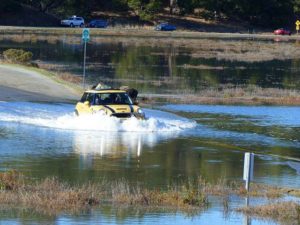
- The road already floods each year during extreme high tides, but the flooding isn’t predictable using tide tables because the weather makes a big difference in the actual water level.
- The communities who live on either side of the State Park are concerned that the flooding may block their use of the road during an emergency. They are also concerned that more frequent flooding associated with sea level rise will cause the road to be closed.
- Scientists, local politicians, and users of the Park are coming together to find mutually beneficial solutions.
Driving Questions
- Is the road affecting the marsh?
- What evidence do you see of the effect?
Investigative Questions
- Are there differences in plant community on either side of the road?
- Are there differences in animal communities on either side of the road?
- Are there difference is water quality (salinity, temperature) on either side of the road?
- Are there differences in water level on either side of the road?
Evidence and data
- Photos of road flooding
- Maps of China Camp State Park
- Plant Community Graphs from Both Sides of the Road
- Preliminary Water Level Graphs from Upland Side of the Road
Activity
Engineering Design Challenge
Design Challenge Specifications and Introduction
Additional packets of photos, articles and information that were used to follow up are combined into one document.
View Additional Materials PDF